This report of an
anomalous event, witnessed by the author, has been
produced for two reasons:
-
As a personal
record for the author;
-
As a witness
record for those persons involved in the
objective, scientific investigation and
research of anomalous events.
This report can be
distributed freely -- but only in its entirety and
in its original, unchanged form -- amongst those
involved in the objective, scientific
investigation and research of anomalous events,
for the purposes of such investigation and
research.
In any commercially
published media (any media that has a fee or any
other monetary-value attached to it), references
to and brief extracts from the text in
this report are permitted. However, substantial
text extracts from this report, in whole or in
part, and reproduction of the whole or part of
each of the three maps (graphics files), are not
permitted without the written permission of the
author-witness.
The author-witness
reserves and asserts his full rights to the
ownership and copyright of this report and its
associated graphics files, but not to those
elements of the graphics files that are copyright
of other parties, as acknowledged in each of the
files. All rights reserved.
This report will
best be viewed with a screen resolution of 1024 x
768 pixels; it was tested satisfactorily in the
Microsoft Internet Explorer version 6.0
environment.
This report should
be read in conjunction with my three accompanying
annotated maps and one aerial view file:
Map 1
Map 2
Map 3
Photo. |
- Geographic Overview (useful as the
main reference throughout);
- Earthquakes and Power Lines;
- Fault Lines.
- Landsat-7 image no. N-10-45_2000 (cropped) |
Copyright © 2004 Roger Gordon Smith.
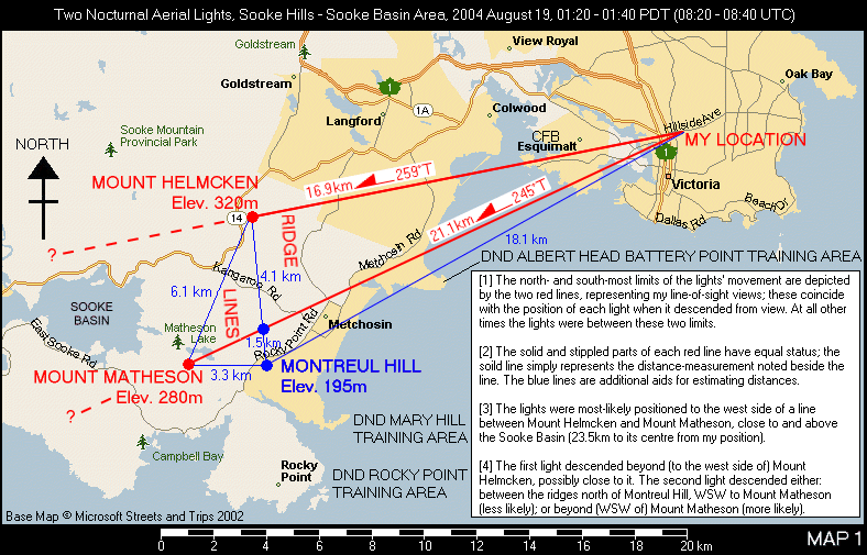
This map is intended
to be referred to as my report is read.
It can be loaded into a separate window for
reference when doing so; click on the map to load
it.
-
The early hours
of Thursday 19 August 2004 were warm and I
could not sleep. This prompted me to get up
and wander to the kitchen. I saw the first of
the lights when entering the kitchen, its
brightness immediately catching my eyes
through the window. I first thought that it
was a new floodlight, brighter than the rest,
on a construction site that was 2km-away. For
the next 20-minutes, from 1:20a.m. to 1:40a.m.
PDT, I was to observe a maximum of two lights
moving around in this part of the western sky.
-
The lights were
bright, white in colour. There was a tint of
amber to their colour, but this may have been
the result of light spillage from the city's
street lights closer to me.
-
From my
viewpoint in Victoria -- a condominium on a
hill, with views across the local rooftops to
the western hills -- the lights appeared as if
above the ridge lines of the Sooke Hills in
Metchosin (the closest ridge lines are
approximately 16km-distant). However, the
lights were most probably positioned west of
these ridge lines, closer to, if not
occasionally above, the Sooke Basin
(23.5km-distant to its centre). The lights
were in close proximity to the sea, part of
the Juan de Fuca Strait.
-
The lights
appeared stationary at times; otherwise, they
appeared slow to moderate in their movement,
ascending and descending while moving north
and south (across my field of view). The
lights made no sudden movements nor abrupt
changes in direction.
-
The maximum
elevation of the lights was approximately
2,000-feet (610-metre), but for most of the
time they were lower, approximately 1,000-feet
(305-metre) or less.
-
The two lights
were present together in the sky for
approximately 7-minutes; just one was seen for
the remainder of the time.
-
The first light
to descend did so beyond (west side of) Mount
Helmcken, possibly close to it.
-
The second
light to descend did so in one of two places:
either beyond (WSW of) Mount Matheson (this
being more likely), or somewhere between the
Metchosin ridges, from approximately
1.5km-north of Montreul Hill to the northern
face of Mount Matheson (less likely).
-
The lights
descended approximately 10-minutes- and
approximately 5km-apart.
-
The first light
to descend may have been associated
with a condensation-like cloud trail. It lit
this up from below when it was behind the
ridge lines, out of my direct view.
-
I have been
interested in astronomy and aviation for most
of my life. I am familiar with observing the
night sky and aircraft at night.
-
I can state
with certainty that the lights were not
astronomical bodies (they were not planets,
stars, meteors, bollides, etc.) nor artificial
satellites.
-
The flight
characteristics (speeds and motions) of the
two lights were not beyond those achievable by
a conventional aircraft that is capable of
stationary and/or very slow flight (to
appear as if stationary), and forward flight
at moderate speeds. A helicopter obviously
comes to mind. However, the required
navigation lights and anti-collision lights --
which I have always seen before -- were not
visible at any time during the duration of my
observations. Additionally, the constant white
lights, never flickering, wavering, nor being
lost from my view as they moved across the
sky, appeared to be omni-directional; this was
not consistent with these being the
uni-directional approach-lighting and/or
landing-lighting of an aircraft in flight.
-
Weather
conditions were good. The western hemisphere
(I could not see the eastern hemisphere from
my location) appeared to be clear of cloud,
certainly in my immediate vicinity of Victoria
and Esquimalt. The glare of local street
lighting diminished the clarity of my views of
the western sky, but there did not appear to
be any cloud farther to the west.
-
This is the
first time I have observed lights in the sky
that I cannot identify nor confidently
explain. They were certainly not astronomical
in nature, at least, not in the conventional
sense, and they were certainly local to the
Sooke Hills area. The observations were
certainly inconsistent with my previous
experiences of conventional aircraft activity;
sufficiently anomalous to warrant my writing
this report. However, I cannot, at this time,
rule out aircraft activity with certainty.
Return to CONTENTS
-
At first, only
one light was visible, it catching my eyes by
its brightness as soon as I looked towards the
kitchen window. After observing this light for
a few minutes -- during which it did not
appear to move -- I went away from the window
to get dressed and to pick up my lightweight
binocular, a Vivitar brand with 10x
magnification and 21mm-diameter objective
lenses (a low resolving power). Upon returning
to the window after approximately 3-minutes
absence, two lights were visible, neither in
the position that I had first seen a light.
-
Each light was
identical in appearance: bright, white in
colour, with a hint of amber. This amber tint
may have been a feature of the light itself,
or the result of a colour cast created by the
spilling of the light from the closer city
lights. The brightness and colour of each
light appeared to be constant, always the same
whether it was stationary or moving.
-
To my unaided
eyes, and also through my binocular, these
lights did not appear to be point sources.
They had a very small (as seen by me)
cross-sectional area; whether this was
circular or slightly elongated (elliptical,
flattened slightly at the top and bottom), I
could not establish with certainty. As an
astronomical analogy, they were like observing
a planet rather than a star (I stress that
this is an analogy; the lights were most
definitely neither of these; indeed, there
were no planets in the sky at the time of my
observations).
-
Excluding the
times I was away from the window (two
occasions; approximately 5-minutes in total),
I observed one or both lights for a total of
approximately 15-minutes. At no time during
this period, despite looking specifically for
such features, did I see any of the navigation
lights and anti-collision lights associated
with commercial, private, and military
aircraft: there were no port (red) and
starboard (green) navigation lights, no
rotating red anti-collision beacons, and no
strobing, white anti-collision lights. I have
occasionally seen aircraft at night from my
same viewing position, they also within the
vicinity of the hills, and their navigation
lights have always been discernible and their
white anti-collision lights have always been
obvious (which is exactly as they should be).
-
I saw nothing
to indicate that the lights were connected to
a solid structure. I saw just the lights
themselves, always visible and constant in
brightness, irrespective of how they moved.
The lights were not occluded by any structural
feature. I also failed to see flickering or
wavering in the lights that would be
indicative of vibrations caused by movement.
-
The size and
brightness of the lights had me mentally
comparing them with, amongst other things: a
floodlight on a construction site 2km-away;
the headlights of a road vehicle on the hills
approximately 16km-away; an aircraft's
approach-, landing-, or auxiliary
spot-lighting, approximately 16km-away. None
of these comparisons was consistent with my
observations. My thoughts about each of these
possibilities -- and others -- are discussed
further in the section, Considerations
During My Observation Period.
-
After the first
light had descended behind the ridge lines, I
could make out its continued descent for a
short while, this due to the changing position
of an upward glow from the light. This
suggested that there was a light mist in its
area, and that the light, in part, had an
upward orientation.
-
After the first
light had just descended behind the ridge
lines, and for one brief moment, it lit up,
from below, the base of a cloud that appeared
to be above the hills. This cloud appeared to
be a narrow strip, extending approximately
west-east, close to or along the track that
the light had appeared to have just moved
along. The cloud curved towards the north at
the easterly end of the lit area. This
observation -- through my binocular -- was
tantalisingly brief. Whether the light was
related to the cause of the cloud trail (a
condensation trail perhaps; if so, the cloud
was much wider than the light itself), or
whether the cloud was there naturally, prior
to the light's passage, I cannot say (small
patches of cloud amongst the hills, at night,
are not uncommon). No cloud was visible at any
other time. When the second light descended
behind the ridge lines, I looked specifically
for such a cloud, but none was seen.
-
I heard no
sound that I could associate with the two
lights. Given the distances to the lights,
this is not significant nor unexpected (it
would, of course, be interesting to know if
anyone living in the vicinity of the Metchosin
hills and Sooke Basin heard or saw anything).
However, I have heard the sound of the
turbo-prop engines on aircraft (usually
twin-engined DHC-8 commercial aircraft),
albeit faintly, when they have passed
approximately above, or a little east-side of,
the Metchosin hills (this is a rarely used
route at night), they being approximately
16km-distant or less.
-
The lights
appeared stationary at times, sometimes for a
few minutes; otherwise, they appeared slow to
moderate in their movement, ascending and
descending while moving across part of my
field of view (a north-south component). There
was no fast or sudden movement, nor any abrupt
change of direction.
-
The lights did
not appear to be moving in formation. Each
light moved, or remained stationery, without
the other appearing to follow suite. The
apparent distance between the two lights was
never constant.
-
One light
subsequently descended beyond (west side of)
Mount Helmcken, which means that it was
farther than 16.9km from my position, but it
was possibly close to the hill (within a few
kilometres perhaps). I did not see this light
again. Its descent also marked the
northern-limit of either lights' travels
across my field of view during my observation
period.
-
The second
light remained visible for about
10-more-minutes. It then descended behind the
ridge lines, but south of the previous light's
descent position. This second light's descent
also marked the southern-limit of either
lights' travels across my field of view during
my observation period. This second light's
descent was either beyond (WSW of) Mount
Matheson (this is more likely), or somewhere
between the Metchosin ridges, from
approximately 1.5km-north of Montreul Hill to
the northern face of Mount Matheson (less
likely). This was the last time I saw either
of the lights. I continued looking for
approximately 20-more-minutes, but I saw none.
-
As each light
descended behind the ridge lines, it did so
quite steeply, with an apparent
southward-trend to its track (they descended
towards my left). The descent angle of each
track across my field of view was at least
approximately 40°-down from the horizontal
(this was for the second light to descend from
view; the first light's descent angle was
steeper, but I had no useful landmarks, which
I had for the second light, to compare its
angle of descent against).
-
As the lights
descended from my view they did not appear to
light any part of the hills that were facing
me.
-
The lights
descended at least 4km-apart, more-likely 5km-
to 6km-apart.
-
I observed the
lights through both an open and a closed
window, this making no significant difference
to the appearance of the lights. All internal
domestic lights were switched off throughout.
-
Weather
conditions were good. The western hemisphere
(I could not see the eastern hemisphere from
my location) looked to be clear of cloud,
certainly in my immediate vicinity of Victoria
and Esquimalt. The glare of the local street
lighting diminished the clarity of my views of
the western sky, but there did not appear to
be any cloud farther to the west.
-
In the
darkness, with no cloud to reflect the urban
light-spill, the ridge lines of the hills
could not be seen against the night sky. This
made it difficult for me to judge the precise
positions of the lights. My view in the
darkness was very 'two-dimensional':
north-south movement (across my field of view)
was easy to determine, but depth perception
(along my line of sight) was minimal.
-
A nearby tree
in a garden 100-metre-away, a lit-up
tower-crane on a building site 2km-away, and
red lights on top of three communication masts
on the ridges in the vicinity of Mount
Helmcken, all provided useful landmarks for my
judging the apparent heights of the lights. In
addition to the communication masts, I knew
that the upper parts of the tree and the crane
were -- in terms of my relative lines-of-sight
-- above the distant ridge lines.
-
The aerial
lights placed the ridge lines into silhouette
when they descended behind them, providing me
with an approximate relative-fix when they did
so.
-
Both lights
most likely descended beyond all the ridge
lines that are visible (in the daylight) to
me, rather than between them. The farthest
ridges that I can see in daylight extend
approximately from Mount Helmcken to Mount
Matheson, 16.9km- to 21.1km-distant. The first
light certainly descended beyond Mount
Helmcken, and the second light most likely
descended beyond Mount Matheson. I formed the
impression from each light's descent that they
were not far beyond the ridges, but also not
so close as to be immediately behind them (the
lights did not light the sides or tops of the
ridge lines facing me, as they descended). An
obvious assumption from the subsequent mapping
of my observations is that the lights were
close to the Sooke Basin, the centre of the
basin being approximately 23.5km-distant from
my position.
-
The apparent
heights of the lights, for most of the time,
placed them along my lines-of-sight close to
where I visualised the ridge lines to
be. The highest I saw the lights was during
their final movements, just before each began
its descent to subsequently pass behind the
ridge lines.
-
The ridge lines
in the area of my observations are no more
than approximately 320-metre (1,050 feet) in
elevation. They are highest at the northern
end of the area in which I saw the lights
(Mount Helmcken) and trend -- with exceptions
-- to lower elevations to the south (for
example, 195-metre (640 feet) at Montreul
Hill).
-
Using the
landmarks I had as a guide, and relating these
and my observations to the mountain ridges
(which I viewed the next morning), I estimate
that the maximum elevation of the lights --
which occurred shortly before each light
descended from view -- was approximately
600-metre (1,969-feet) to 668-metre (approx.
2,192-feet). This approximation is based on
the assumption that the lights were at a
distance from me that was equal to, or
between, that of Mount Matheson (21.1km-away)
and the centre of Sooke Basin (approximately
23.5km-away). For most of the time the lights
were lower than this, appearing to be
approximately at the height of the ridge lines
as seen from my position; they were therefore
most likely to have been close to
approximately 320-metre (1,050-feet) and less
for much of the time.
-
Any movement
the lights may have made along my line of
sight (that is, towards or away from me;
west-east) was not obvious. Front-to-back
depth of vision was extremely difficult to
judge. If there was front-to-back movement
relative to me, it was not sufficient to
manifest itself by a change in the apparent
brightness and apparent size of the lights.
The lights appeared constant in their
brightness and size throughout.
-
Having been
interested in astronomy for most of my life, I
am familiar with observing the night sky. The
lights I saw were definitely not
stars, planets, meteors, bollides, or
artificial satellites. There were actually no
planets in the sky at the time of my
observations.
-
The lights were
clearly local, somewhere close to the Sooke
Hills in Metchosin and the Sooke Basin. One
light, for example, lit up, from below, the
base of a cloud that appeared to be above the
hills.
-
When I first
saw a light, its apparent low height and
line-of-sight made it appear to be just above
a construction site 2km-away. I considered the
possibility that it was a new floodlight on
the construction sight, noticeably brighter
than the rest, but the subsequent events ruled
this out.
-
I considered
the possibility that I was seeing the
headlights of a road vehicle on the distant
hills, they pointing directly along my
line-of-sight. I have seen such vehicle
lights, and confirmed them as such, once
before. Subsequent viewing ruled this out, not
least the observations that each light was
definitely in the air.
-
The flight
characteristics of each light could certainly
have been achieved with a conventional
helicopter; less-likely, but perhaps still
possible, with an airship (dirigible),
autogyro, or a fixed-wing aircraft capable of
very slow flight (an aircraft moving very
slowly and directly towards me,
at distance, could possibly appear stationary;
but for periods of up to 3-minutes?). However,
this aircraft analogy becomes inconsistent
when the appearance of the lights is
considered. There were no navigation and
anti-collision lights, just the constant white
lights†. The lights were always
orientated exactly along my
lines-of-sight, even when they were moving
4km- to 6km-across my field of view.
This suggests omni-directional lighting (at
least in my horizontal plane), but the
approach-, landing-, and spot-lighting on an
aircraft is, to the best of my knowledge, all
uni-directional, and I would expect such
lighting, when moving across my line-of-sight,
to be visible for only part of the time, to
quickly be lost from view. The lights also
moved smoothly, there being no flickering,
wavering, or undulating to suggest vibrations
and bouncing caused by movement.
† Through my
experiences with observing aircraft at
night, I am aware that the red and green
navigation lights, and the red
anti-collision beacons, can sometimes not be
seen due to the overwhelming brightness of
the approach- and landing-lighting; however,
such lighting has become visible when the
aircraft has changed its orientation with
respect to me (usually, it requires only a
little movement in an aircraft's orientation
for this to occur). To therefore view two
aerial lights, for a total of approximately
15-minutes, moving across approximately 14°
of my field of view, and to not see the
navigation and beacon lights, suggests to me
that they were not actually present. I am
also aware that not all aircraft have
flashing (strobing) white anti-collision
lights, this being the case with some
smaller, private, general aviation craft.
-
Although the
movements and speeds of the lights were
inconsistent with an unpowered craft, I did
specifically look for parts of such a craft,
such as a balloon canopy, lit from below or
within by a flame or by the visible white
light. Nothing was seen. Certainly, flying a
hot air balloon at night would not be a wise
action.
-
The lights
neither looked nor moved like flares, with or
without parachutes. I will qualify this by
saying that I have not seen a flare at
night, but these were not what I would imagine
them to be like. The lights were constant in
brightness, not flickering; constant in size;
had no fuzzy tails; displayed no downward
trending flight, rather, frequent changes in
direction of travel (up as well as down, left
and right, and long stationary periods); the
stationary periods lasted sometimes for up to
approximately 3-minutes. I am not aware of the
wind conditions above the hills and in the
Sooke Basin at the times of my observations,
but for a balmy night in Summer I would be
surprised if the wind was not calm or of a
very low speed. Additionally, this was at a
time when a significant fire-hazard-warning
was in effect due to the dry forests; the use
of flares over the forested hills would not
have been a wise action.
-
This
sub-section considers military aircraft. It
should be noted that all the inconsistencies I
have raised with respect to the lights being
carried by an aircraft (any aircraft)
remain, unless military aircraft are permitted
to fly without navigation and anti-collision
lighting in peacetime in civilian areas.
Additionally, the purpose of bright,
omni-directional lighting on a military
aircraft is not apparent (to the best of my
knowledge, search lights -- used for air-sea
rescue -- for example, are uni-directional).
-
The lights were
observed in an area that is near to or not far
from the Canadian Forces Base Esquimalt and
three Department of National Defence training
areas, but they were not within or above any
of these areas. If the military was carrying
out night activities, it was doing so outside
its training areas. I have written, via
e-mail, to CFB Esquimalt, explaining the
nature of my observations and asking if it had
any military activities or exercises in this
area at the time of my observations. I also
asked it to confirm the lighting used on
Canadian military aircraft at night. It has
not replied. I am disappointed that it has not
even had the courtesy to acknowledge my
request.
-
I am aware that
the Canadian military has, or has had, on
trials, a small number of Uninhabited
Aerial Vehicles (UAVs; these were
previously referred to by the military as Unmanned
Aerial Vehicles). These are relatively
light, radio-controlled (remotely-piloted)
aircraft that can be used to carry various
payloads for aerial reconnaissance. At least
five different models have been used, four of
which have been fixed-wing aircraft, the
other, rotary.
-
One fixed-wing
UAV has been used at least once on Vancouver
Island, in an exercise during the daylight
hours off the coast of Tofino in 2003. The
Department of National Defence issues news
releases about these tests; however, there
have been no DND news releases to suggest that
any UAV was present and in use in the Victoria
area, at any time.
-
A major trial
involving UAVs was held on Baffin Island and
in Atlantic Canada from 22 August to 31 August
2004, this starting 3-days after my sighting
of the lights on the west coast.
- Refer to the References
section for further details.
-
There are at
least four communication masts on the ridge
lines, three with red lighting, positioned at
and north-of the north end of the area in
which the lights travelled. I am not familiar
with the purposes of these masts, other than
one use is for weather reporting for shipping.
Despite the first light descending beyond this
area, I observed nothing over the 15-minutes
of direct viewing to suggest that the lights
and the masts had any direct association with
each other.
-
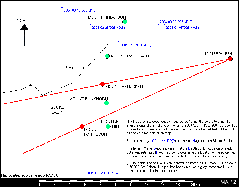
Refer to Map
2. I am aware of just one electricity
power line in this region of the Sooke Hills,
this along the north side of the west end of
Sooke Basin, turning approximately
north-eastwards, to pass approximately
3.9km-west of Mount Helmcken. Despite the
first light descending along my line-of-sight
in part of this area, I observed nothing over
the 15-minutes of direct viewing to suggest
that the lights and the power line had any
direct association with each other.
-
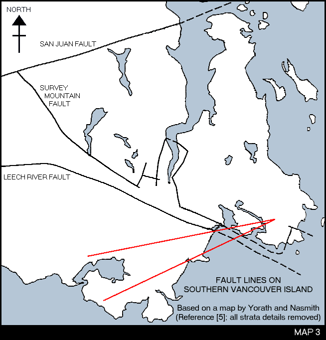
I am aware that
aerial lights have sometimes been reported
above active fault lines at the Earth's
surface, and that the west coast of Canada is
one of the most seismically active areas in
the world. The lights that I observed did not
have me suspecting them, at any time, to be
related to seismic activity (not glowing
gases, such as methane, for example). However,
I did, for completeness, check the earthquake
activity records produced by the Pacific
Geoscience Centre in Sidney, BC.
-
Refer to Map
2. There has been no earthquake activity
in the immediate area in which the lights were
seen, for the 12-months prior and the 2-months
subsequent to the lights being seen. The two
closest earthquakes in this period have been
5.6km to the south side of Mount Matheson, and
5.9km to the north side of Mount Helmcken;
these were very low magnitude events (0.8 and
1.0 on the Richter Scale), and, for the one
that had its depth calculated, 4km-deep (it is
often not possible to calculate the depth of
an earthquake; in such cases an estimated
depth is assigned to fix the foci, so
that the position of the epicentre can be
given).
-
Refer to Map
3. There is a major fault line, the
Leech River Fault, that, at its closest,
passes approximately 6km-north of the northern
limit of the area in which the lights were
seen. The Leech River Fault was
created at least 40-million-years ago and it
has been inactive for a very long time (there
has certainly been no activity since
settlements began in this region; this is also
true of the other major fault lines in this
region). This fault line is inclined at
approximately 60°-down from the horizontal at
the surface, towards the north (it lessens to
an inclination of 35° to 45° at a depth of
approximately 3km). Although the fault line
itself is inactive, deep earthquakes of low
magnitude are not uncommon below its surface
trace (See Map 2; the three
earthquakes in a line to the north of the area
in which the lights were seen, from the south
to the west sides of Mount Finlayson).
Information source: Yorath and Nasmith,
reference [5], pages 39-40, 63 (map).
-
This is the
first time I have observed lights in the sky
that I cannot identify nor confidently
explain. They were certainly not astronomical
in nature, at least, not in the conventional
sense, and they were certainly local to the
Sooke Hills area. The observations were
certainly inconsistent with my previous
experiences of conventional aircraft activity;
sufficiently anomalous to warrant my writing
this report. However, I cannot, at this time,
rule out aircraft activity with certainty.
Return to CONTENTS
[The
witness-author's personal details have been
withheld from this web publication].
Return to CONTENTS
All references
were correct on the date of completion of this
report.
-
Natural
Resources Canada, National Topographic System
(NTS) maps:
Sheet 92B/5, Sooke, 1:50,000.
Sheet 92B/6, Victoria, 1:50,000.
-
Microsoft
Streets and Trips 2002 software. Used
for the base of my Map 1.
-
Natural Resources Canada,
Geological Survey of Canada, Sidney Subdivision
(also known as the Pacific Geoscience Centre): Preliminary Earthquake
List: Last 5 Years in Western Canada; http://www.pgc.nrcan.gc.ca/seismo/recent/wc.5yr.list.html
-
Aeronautical
navigation-mapping software, NAV
3.0 by Ted Wright. The Pacific
Geoscience Centre's data (see above) were
downloaded, reformatted, and used in the NAV system. NAV, together
with a separate graphics-editor, was used to
produce the details on my Map 2. NAV is freeware, designed as
a navigational-aid viewer and flight planner
for use with the Microsoft Flight Simulator.
However, I have found much use for it with
real-life, geographic data, aeronautical and
otherwise (MS Flight Simulator is not
required, but experience and skills beyond
normal user-level are necessary to format the
data for use within the system). Further
details: http://nav.consequential.org/
-
Book. The
Geology of Southern Vancouver Island: A
Field Guide, by C.J. Yorath and H.W.
Nasmith. Orca Book Publishers, 1995. ISBN
1-55143-032-0. Used for fault line reference
(pp 39-40) and the basis for my Map 3
(page 63).
-
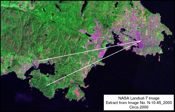
NASA Landsat-7
image, N-10-45_2000, from the web site: https://zulu.ssc.nasa.gov/mrsid/
- Department of
National Defence / Canadian Forces (DND/CF)
Media Advisory: MA-03.021, 9 July 2003: Canadian Forces Test UAV on
Vancouver Island; http://www.forces.gc.ca/site/newsroom/view_news_e.asp?id=1139
- CFB Esquimalt
newspaper, The Lookout, July 2003; a
summary of the testing of a UAV on Vancouver
Island: Not your
ordinary remote controlled airplane; http://www.forces.gc.ca/dcds/units/cfec/pages/events/uav_e.asp
- Department of
National Defence / Canadian Forces (DND/CF)
Media Advisory NR–04.036, 4 May 2004: Canadian Forces Purchases Mini UAV
System; http://www.forces.gc.ca/site/Newsroom/view_news_e.asp?id=1368
- Department of
National Defence / Canadian Forces (DND/CF)
Media Advisory NR–04.063, 19 August 2004:
Canadian Forces to Conduct Major UAV Trial;
http://www.forces.gc.ca/site/Newsroom/view_news_e.asp?id=1433
- E-mail address of
CFB Esquimalt: cfbesquimalt@shaw.ca
- The Canadian
American Strategic Review (CASR), based at
the Simon Fraser University in Burnaby, BC,
Canada: Canadian
Forces Unmanned Aerial Vehicle (UAV) Project;
http://www.sfu.ca/casr/101-uav1.htm
- The Canadian
American Strategic Review (CASR) based at
the Simon Fraser University in Burnaby, BC,
Canada: Canadian Forces Tactical UAV --
CU-161 Sperwer Background; http://www.sfu.ca/casr/101-uav6.htm
- The Canadian
American Strategic Review (CASR) based at
the Simon Fraser University in Burnaby, BC,
Canada: Canadian Forces Uninhabited Aerial
Vehicle -- the ACR Silver Fox; http://www.sfu.ca/casr/101-uav7.htm
- The Canadian
American Strategic Review (CASR) based at
the Simon Fraser University in Burnaby, BC,
Canada: Canadian
Forces Uninhabited Aerial Vehicle -- the
CU-163 Altair; http://www.sfu.ca/casr/101-uav8.htm
- The Canadian
American Strategic Review (CASR) based at
the Simon Fraser University in Burnaby, BC,
Canada: Canadian Forces Uninhabited Aerial
Vehicle Trials & Developments; http://www.sfu.ca/casr/101-uav4.htm
Return to CONTENTS
|
 RETURN TO HISTORY INDEX